- Home Page /
- Electronics /
- Car & Vehicle Electronics /
- Marine Electronics /
- Marine GPS Accessories /
- C-MAP Reveal Coastal - Chesapeake Bay to The ...
0 ratings

Item #:
44199053
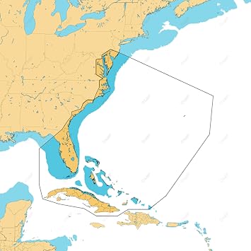
C-MAP Reveal Coastal - Chesapeake Bay to The Bahamas, Map Card for Marine GPS Navigation
Item #:
44199053
ETB 50908
Price Details
Excluding Shipping & Custom charges ( Shipping and custom charges will be calculated on checkout )
*All items will import from US
0 ratings
Write a review
In stock
QTY:
Order now and get it around Thursday, July 02
Secured transaction
Ubuy works hard to protect your security and privacy. Our advanced payment security system ensures confidentiality by encrypting your information during transmission using AES (Advanced Encryption Standards) and SSL (Secure Socket Layer) protocols. Your payment details are 100% secure as we do not share your payment details with third party sellers.
Our Top Logistics Partners
C-MAP delivers navigational marine charts with top-quality global data for lakes, coastlines and oceans so you know how to maneuver the waters no matter if you are boating or engaging in watersports.
Fast
Shipping
Free
Return*
Secure Packaging
100% Original Products
PCI DSS Compliance

ISO 27001 Certified
Note: Step Down Voltage Transformer required for using electronics products of US store (110-120). Recommended power converters Buy Now.


What Stands Out
Detailed Coverage
C-MAP Reveal Coastal offers extensive mapping from Chesapeake Bay to The Bahamas, ensuring boaters have access to crucial navigation details across this vital marine corridor.
Easy Integration
This map card seamlessly integrates with various marine GPS devices, allowing for straightforward installation and user-friendly operation, enhancing navigation experiences for both new and seasoned mariners.
Enhanced Features
Utilizing innovative technology, C-MAP Reveal Coastal provides real-time updates and detailed information on underwater features, helping users navigate safely and effectively while discovering new fishing spots.
Product Details
- 3D rendered land and underwater elevation with shaded relief
- Accurate and up-to-date vector chart detail from official Hydrographic Office information
- High-resolution bathymetry for identifying shallow areas, drop-offs, and ledges
- Custom depth shading for setting safety depth and creating custom views
- Dynamic raster charts with traditional chart look and feel
- Global navigational marine charts with top-quality data for lakes, coastlines, and oceans
| Item Weight | 0.5 lbs (230 grams) |
Who Should Buy?

-
Boating Enthusiasts
Ideal for recreational boaters who navigate coastal waters, providing detailed maps and reliable navigation features.
-
Fishermen
Great for anglers seeking detailed topographic maps and fishing hotspots in the Chesapeake Bay to Bahamas regions.
-
Marine Professionals
Essential for maritime professionals that require precise navigation tools for charting routes and monitoring coastal conditions.

-
Inland Navigators
Not suitable for users focused on inland waterways, as coverage is limited to coastal and offshore areas.
-
Non-Technical Users
May be challenging for users without prior GPS or technical navigation experience, as features can be complex.
-
Budget-Conscious Buyers
Could be an expensive option for casual users who do not frequently require advanced navigation capabilities.
Product Description
C-MAP Reveal Coastal - Chesapeake Bay to The Bahamas, Map Card for Marine GPS Navigation
Have any Query? Chat with us
Customer Questions & Answers
-
Question:
What areas does the C-MAP Reveal Coastal map card cover?
Answer: The C-MAP Reveal Coastal map card provides detailed coverage from the Chesapeake Bay all the way to Ethiopia. This extensive coverage includes various coastal waters, ensuring that mariners have access to important navigational information across a wide area. This map card offers high-resolution charts, making it ideal for both professional and recreational boaters navigating in these regions. -
Question:
What type of information can I expect from the C-MAP Reveal Coastal maps?
Answer: The C-MAP Reveal Coastal maps include crucial navigational data such as water depths, buoys, and markers, along with detailed chart features like contour lines and rock formations. This level of detail enhances navigation safety and helps in planning fishing trips or recreational outings. Moreover, these maps are integrated with the latest updates to ensure accuracy on the water. -
Question:
What GPS devices are compatible with C-MAP Reveal Coastal map cards?
Answer: C-MAP Reveal Coastal map cards are compatible with a wide range of marine GPS devices from various manufacturers. Devices from leading brands like Garmin, Lowrance, and Simrad support these map cards. Just ensure that your device supports C-MAP chart formats for optimal performance, allowing users to easily access rich data while navigating. -
Question:
How can the C-MAP Reveal Coastal map card enhance my boating experience?
Answer: Using the C-MAP Reveal Coastal map card can significantly enhance your boating experience by providing precise navigational aids, reducing the risk of running aground, and allowing you to find the best spots for fishing or exploring coastal areas. With its detailed insights, you'll feel more confident while navigating unfamiliar waters and enjoy your time on the water even more. -
Question:
Can the C-MAP Reveal Coastal map card be updated?
Answer: Yes, the C-MAP Reveal Coastal map card can be updated to incorporate the latest navigational data and features. Regular updates are particularly important for marine navigation, ensuring mariners have access to the most accurate charts. Users can check for updates through the C-MAP platform and enjoy enhanced features as they become available. -
Question:
Is the C-MAP Reveal Coastal map card user-friendly?
Answer: Absolutely! The C-MAP Reveal Coastal map card is designed for user-friendliness, providing intuitive navigation tools that can easily be understood by both seasoned sailors and novice boaters. The clear graphics and overlays make it simple to interpret vital information quickly, allowing you to focus on enjoying your time on the water. -
Question:
What kind of format does the C-MAP Reveal Coastal map card use?
Answer: The C-MAP Reveal Coastal map card uses the C-MAP chart format, which is specifically designed for marine navigation. This ensures compatibility with various marine GPS devices and provides features such as dynamic overlays, 3D visualizations, and detailed charts. This format enhances the navigational experience by making data more accessible and easier to analyze. -
Question:
Can I use the C-MAP Reveal Coastal map card for fishing?
Answer: Yes, the C-MAP Reveal Coastal map card is an excellent tool for fishing enthusiasts. With detailed bathymetric data, users can locate underwater structures where fish are likely to gather. The map also highlights areas such as channels and reefs, giving anglers valuable insights into potential fishing hotspots, enhancing both recreational and sport fishing experiences. -
Question:
What additional features does the C-MAP Reveal Coastal map card provide?
Answer: In addition to standard navigational information, the C-MAP Reveal Coastal map card offers features like satellite imagery and detailed chart overlays, which can greatly enhance situational awareness on the water. These features help users comprehend their surroundings better, allowing for safer and more enjoyable trips whether for leisure or professional purposes. -
Question:
Where can I buy C-MAP Reveal Coastal - Chesapeake Bay to Ethiopia, Map Card for Marine GPS Navigation?
Answer: You can purchase the C-MAP Reveal Coastal map card at Ubuy, which provides a variety of options and competitive pricing. Ubuy is known for its customer service and ease of shopping, ensuring you can find the right map card with minimal hassle. Ubuy also frequently stocks new arrivals, making it a reliable place for your marine navigation needs.
C-MAP Marine GPS Accessories Editorial Review
The C-MAP Reveal Coastal Charts for Marine GPS Navigation offer high-resolution bathymetry, shaded relief, vectors and custom depth shading. The Chart Explorer website allows for coverage detail information. The installation process is simple, just insert the SD card into the plotter and select it from the menu. However, customer experience with this product has been mixed. Some customers had difficulty with installation and compatibility with their GPS chart plotters. Others have reported that the charts do not work correctly and that the graphics take time to build as the user is moving. Additionally, customer service for C-MAP has been rated poorly, with many customers expressing frustration with wait times and unhelpful service. Overall, the C-MAP Reveal Coastal Charts have useful features such as high-resolution bathymetry and shaded relief, but customers should be aware of potential compatibility issues and the possibility of poor customer service.
Customer Reviews & Ratings
1 customers ratings
-
5 Star
100%
-
4 Star
0%
-
3 Star
0%
-
2 Star
0%
-
1 Star
0%
Review this product
Share your thoughts with other customers
Pros
- High-resolution bathymetry
- Shaded relief
- Custom depth shading
Cons
- Graphics take time to build
Product Price History
Important information
- Limitations : For products shipped internationally, please note that any manufacturer warranty may not be valid; manufacturer service options may not be available; product manuals, instructions, and safety warnings may not be in destination country languages; the products (and accompanying materials) may not be designed in accordance with destination country standards, specifications, and labeling requirements; and the products may not conform to destination country voltage and other electrical standards (requiring use of an adapter or converter if appropriate). The recipient is responsible for assuring that the product can be lawfully imported to the destination country. When ordering from Ubuy or its affiliates, the recipient is the importer of record and must comply with all laws and regulations of the destination country.
- Not all the products listed on Ubuy are for sale, as Ubuy is a global search engine. Products are subject to export/trade regulations.
ETB 50908
Order now and get it around Thursday, July 02
This item is not restrict in my country.(Please click on above link if this item is not restrict in your country, So our team will review and allow.)
QTY:
Secured transaction
Ubuy works hard to protect your security and privacy. Our advanced payment security system ensures confidentiality by encrypting your information during transmission using AES (Advanced Encryption Standards) and SSL (Secure Socket Layer) protocols. Your payment details are 100% secure as we do not share your payment details with third party sellers.
Our Top Logistics Partners
Fastest cross-border delivery
Features & Benefits
- Detailed coverage of over 8,000 lakes in the USA alone and over 7.2 Million points of interest globally
- Compatible with more marine brands than any other company
- Trusted provider for the commercial marine sector, with additional focus on weather conditions and routing analyses
- Shaded Relief
- Full-Featured Vector Charts
- High-Res Bathy
- Custom Depth Shading
- Dynamic Raster Charts